
|
|
1815 Surveying Michigan 200th Anniversary Commemoration
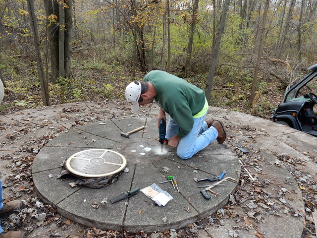
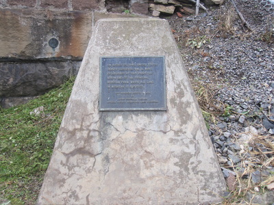
PRESS RELEASE Sunday, Oct. 11 at 2 p.m. This year marks the 200th anniversary of the setting of the surveying lines for Michigan. In 1785 a public land survey proposed by Thomas Jefferson was an efficient method for the establishment of land boundaries and even today affects all land owners. In 1807, the west boundary of the Treaty of Detroit was selected as the line for the Michigan Principal Meridian; the southernmost (and beginning point) of the meridian was set in 1815 at Fort Defiance, Ohio and the northernmost (and final) point was set in 1840 in Sault Ste. Marie. Join us for a bicentennial commemoration of the surveying of Michigan! To celebrate this anniversary, the volunteer group 1815 Surveying Michigan will host a 30-40 minute informative presentation on the history of surveying in Michigan and its relevance for today at Leslie High School on Sunday, Oct. 11 at 2 p.m. Afterward, attendees will be transported by bus to the Meridian Baseline State Park, where the Meridian and Baseline initial point markers rest. These points are the basis for all land surveys in Michigan and parts of Ohio. Today, property descriptions in Michigan are referenced from these points. Meridian Baseline State Park, where the markers rest, consists of 86 acres of land (acquired 1960-1970) that was landlocked for many years without public access. In 2014, the Michigan Department of Natural Resources was able to acquire additional property so that people can access the park from Meridian Road near the Jackson-Ingham County line. A trail has been cleared and a 10-car parking lot for day visitors has been constructed for those who wish to see this historic landmark and learn about its significance. Attendees of the Oct 11 event are invited to go to the park via provided bus service. A new trail and bridge are expected to be completed but you are encouraged to wear footwear suitable for rough terrain and able to walk a distance of one-half mile each way. The trail is not accessible for wheelchairs or those with physical disabilities at this time. Since the parking lot at Meridian Baseline State Park is very small and safety is paramount, attendees of this commemorative event are asked to ride the buses provided, to and from the Park. Parking along Meridian Road is strongly discouraged and parking inside Meridian Baseline State Park will be reserved for the buses transporting people to and from Leslie High School. The volunteer group 1815 Surveying Michigan, the Michigan Department of Natural Resources and the Michigan Society of Professional Surveyors have been responsible for development of the park, purchasing a historic marker and replacing a missing Initial Point Marker at Meridian Baseline State Park. In addition, the park and this commemoration has been generously supported by numerous community and professional organizations and individuals within Jackson and Ingham Counties as well as from around the State of Michigan. FOR more information on the 1815 Surveying Michigan project and the commemoration event, please visit www.1815surveyingmichigan.weebly.com; the group’s Facebook page, 1815 Surveying Michigan; or email [email protected] or contact Debby Sears at the Jackson District Library, 517- 788-4087. |
Email [email protected] facebook 1815 Surveying Michigan SUPPORTING ORGANIZATIONS BAYLISS PUBLIC LIBRARY ( SAULT STE. MARIE MICHIGAN) CHIPPEWA COUNTY HISTORICAL SOCIETY ELLA SHARP MUSEUM FRIENDS OF WALKER TAVERN (HISTORIC SITE) HANOVER HORTON AREA HISTORICAL SOCIETY INGHAM COUNTY HISTORICAL COMMISSION JACKSON COUNTY GENEALOGICAL SOCIETY JACKSON COUNTY HISTORY SOCIETY JACKSON DISTRICT LIBRARY LESLIE AREA HISTORICAL SOCIETY MASON AREA HISTORICAL SOCIETY MICHIGAN DEPARTMENT OF NATURAL RESOURCES MICHIGAN SOCIETY OF PROFESSIONAL SURVEYORS MONROE COUNTY MEUSEUM TOMPKINS CENTER HISTORICAL SOCIETY WARREN HISTORICAL & GENEALOGICAL SOCIETY WATERLOO FARM MUSEUM AND INDIVIDUALS LIKE YOU THE MICHIGAN HISTORICAL COMMISSION HAS ACCEPTED THE APPLICATION FOR THE HISTORICAL MARKER TO BE PLACED AT THE MERIDIAN-BASELINE STATE PARK THE TEXT HAS BEEN APPROVED, MARKER ON ORDER. AND WILL BE ERECTED THIS SPRING ( DATE TO BE ANNOUNCED) THE NORTHERN INITAL POINT MARKER HAS BEEN REPLACED OUR MISSION
TO HAVE INTERRUPTION PANELS PLACED IN THE PARK, AND PARK BENCHS ALONG THE TRAIL, AND PICNIC TABLES YOUR DONATION IS NEEDED . PLEASE MAKE ALL DONATION TO: JACKSON COUNTY HISTORICAL SOCIETY TO THE 1815 SUVEYING MICHIGAN PROJECT. JACKSON COUNTY HISTORICAL SOCIETY IS A 501(C3) ORGANIZATION. PLEASE MAKE CHECKS PAYABLE TO JACKSON COUNTY HISTORICAL SOCIETY 244 W MICHIGAN AVE JACKSON MI 49202 |
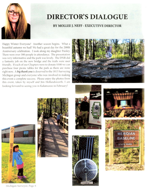
A Page from Michigan Surveyor.
An official publication of the Michigan Society of Professional Surveyors
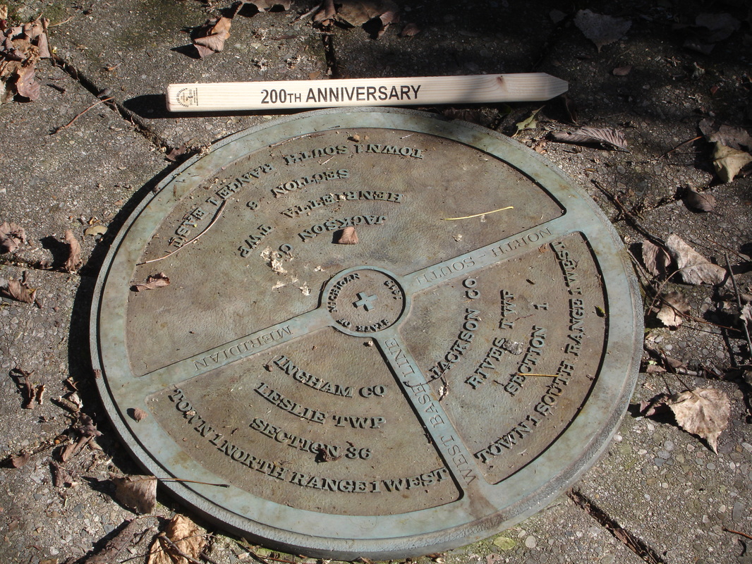
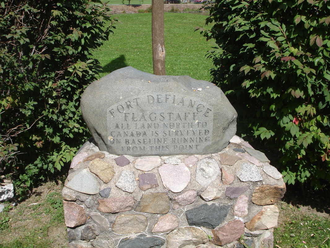
The Northernmost Point The Initial Point Beginning point of Meridian
Sault Ste. Marie Michigan Meridian & Baseline Marker Fort Defiance, Defiance Ohio
Sault Ste. Marie Michigan Meridian & Baseline Marker Fort Defiance, Defiance Ohio
